


Kaliakra
Калиакра

Worth a detour
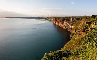
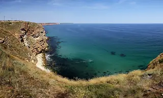
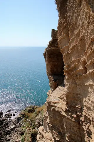
The cape is a blade of reddish rock pushing about two kilometres into the Black Sea with seventy-metre cliffs on both sides and a fortress wall drawn across the narrowest point. In the fourteenth century this was the seat of Dobrotitsa's despotate. Now it is a reserve, a road, a chapel and a very good walk. Late afternoon is when the rock actually turns red rather than merely warm.
Story
Background
People have used the headland since at least the fourth century BC, when the Thracian settlement of Tirizis stood on it. Its high point came in the 1300s under Dobrotitsa, who ruled this coast from here, minted his own coins and kept galleys below. The Ottomans took it in 1393 or 1394. What survives is foundations, cisterns and stretches of wall rather than standing buildings — the drama is entirely in the site.
A monument near the entrance marks the legend of the forty maidens who are said to have tied their hair together and walked into the sea rather than be taken. There is no documentary basis for it. It is a story the place grew, and it gets told at every stop on the cape.
The whole headland has been a nature and archaeological reserve since 1960 — some 687 hectares, including a strip of sea, with over four hundred plant species of which nearly fifty are rare or protected. It sits under the Via Pontica, so autumn brings raptors and storks over, and short-beaked common dolphins are regular below the cliffs. A chapel to St Nicholas was built out at the tip in 1993. Go late: the light after five does something to the iron in the rock that midday cannot.
From open data
Dates and details
- Built
- September 27, 1941
- Part of
- 100 Tourist Sites of Bulgaria
- On
- Black Sea
- Municipality
- Dobrich
- Elevation
- 19 m
- Area
- 7.1 km²
English Wikipedia
Kaliakra is a cape in the Southern Dobruja region of the northern Bulgarian Black Sea Coast, which ends with a long and narrow headland 12 kilometres (7 mi) east of Kavarna, 60 kilometres (37 mi) northeast of Varna and 65 kilometres (40 mi) southwest of Mangalia. The coast is steep with vertical cliffs reaching 70 metres (230 ft) down to the sea. Kaliakra is a nature reserve, where dolphins and cormorants can be observed.
English Wikipedia · CC BY-SA 4.0
Photographs




Where the information comes from
About & sources
Last checked Sep 16, 2026
Descriptions, recommendations and the audio scripts are written for this guide.
Report a problem