


Bulgarka Nature Park
Българка

Worth a detour
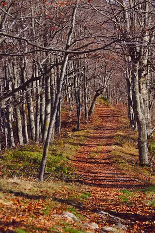
Declared in 2002 to protect the beech forests on the northern flank of the central Balkan range, the park covers a little over 21,000 hectares across Gabrovo and Tryavna. It is less a place you visit than the frame around several places you probably already intend to: the Etar open-air museum, Sokolski Monastery, and the ridge above Shipka all sit inside it. Best in October, when the beech turns.
Story
Background
Bulgarka was established on 9 August 2002, comparatively late, and its purpose is the beech. The northern slope of Stara Planina above Gabrovo and Tryavna carries some of the best-developed beech forest in the country, and the designation was as much about holding that landscape together as about protecting any single rarity. Within the boundary sit several smaller protected areas and natural features — old yew stands, a big individual beech, the rock outcrops known as Vikanata Skala.
What gives the park its character, though, is how much human history is folded into it. The Etar museum and its water-powered workshops are inside the boundary. So is Sokolski Monastery, on a shoulder above Gabrovo, which sheltered insurgents in 1876 and has a well-known domed fountain in its yard. So is a large part of the Shipka–Buzludzha national park-museum along the ridge. This is not wilderness; it is worked mountain country that happens to have kept its trees.
Practically, the useful way to think about it is as a driving and walking area rather than a single site. There are marked trails linking Gabrovo, Etar, Sokolski and the ridge, and the road over the Shipka pass runs through the middle of it. Autumn is the season — beech forest in October is the reason this boundary was drawn.
From open data
Dates and details
- Built
- August 9, 2002
- Area
- 220 km²
English Wikipedia
The Bulgarka Natural Park is a Bulgarian nature park on the northern slopes of the Balkan Mountains (Stara Planina), occupying 22,000 hectares of territory in the central and eastern part of the mountains between the cities of Gabrovo and Kazanluk. Located between the steep topography of the Central Balkan and the significantly lower and sloping eastern part of Stara Planina, the region is characterized by significant diversity in terrain. This supports a rich diversity in flora and fauna.
English Wikipedia · CC BY-SA 4.0
Photographs




Where the information comes from
About & sources
Last checked Sep 17, 2026
Descriptions, recommendations and the audio scripts are written for this guide.
Report a problem